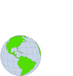
Orbit with the La Trobe Eagle

 La Trobe University is a major facility in the plans for
the Australian Cooperative Research Centre for Satellite Systems (CRCSS).
La Trobe University is a major facility in the plans for
the Australian Cooperative Research Centre for Satellite Systems (CRCSS).
To establish the CRCSS, the Federal government has already
pledged $20 million over seven years.
Plans call for the CRCSS to launch its first satellite, FedSat 1 in time
for the centenary of Federation in 2001.
La Trobe is the only Victorian university that is in the CRCSS.
Once the CRCSS is formally established at the end of 1997,
there will be new
opportunities in Space Science and Technology
for both undergraduate and research
students.
Subject to the final exchange of contracts formally establishing
the CRC for Satellite Systems,
top-up scholarships will be available for post-graduate students.
Contact the listed researchers for details.
 CRC for Satellite Systems
Listed Researchers in ATMOZ-GPS
Probing the atmosphere and ionosphere using GPS Signals
Dr Elizabeth Essex
Space Physics Department
Faculty of Science, Technology and Engineering
La Trobe University
Melbourne, Australia 3083
|
Dr Essex is the research manager for GPS Signal Science
within the CRC for Satellite Systems.
She is directing a program that uses
GPS signals, received a ground stations in Australia and Antarctica,
to probe the geosphere.
Experiments on-board FedSat 1 will
study the occultation of GPS SV signals,
probing all levels of the atmosphere.
- Space based and Ground based Computerised Ionospheric Tomography
- Mapping the Ionosphere in the Australian and Antarctic Region
See the text summary of her research projects.
|
Dr Harvey A. Cohen
Computer Science and Computer Engineering
La Trobe University
|
Dr Cohen is a listed researcher in the CRC concerned with
scientific platform and computing.
These experiments lead to the production of
terabytes of data that need to be accessed
by researchers.
FedSat 1 and other satellites to be launched by the CRCSS
have to form an integrated system as far as communication, control, and
data collection
is concerned. Within this system are FedSat 1, the 24 SV GPS satellites, a
Singapore LEO satellite to launched shortly, and ground stations.
Sophisticated system simulators have be developed to
evaluate experimental designs and constraints for on-board experiments.
The great amount of atmosphere and image data collected by our LEO satellite
during each orbit has to be massaged and compressed on-board so that it can be sent
to a ground station during the brief time that the satellite is overhead.
See the text summary of his
CRCSS related research projects.
Dr Cohen is webmaster for these CRCSS web pages,
as well as :
the Image Engineering Index
|
ATMOZ-GPS Project
Sounding the Atmosphere
using GPS Signals
The objective of the GPS/Occultation experiment is to use signals from
GPS satellites almost occulted by the Earth.
Such signals have a path an important
component of which is through the lower atmosphere.
GPS signals indicate to remarkable precision
the instant of trasnmission, and we know with precision the location
of the SV, and of the receiving satellite
Using near-occultation data we will be able to take temperature, pressure, and other measurements at hundreds of points on the Earth every day, extending from near the surface up through the ionosphere.
See
Overview of GPS/MET
University Corporation for Atmospheric Research.
|
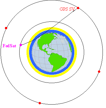
FedSat is shown in low earth orbit about the earth,
atmosphere and ionosphere indicated.
In a larger orbit of 12 hours period are shown
the 4 GPS SV's (Space Vehicles) that traverse the same orbit.
The total GPS sysytem involves 24 SVs in 6 orbits
inclined at 55 degrees to the equator.
Just one of the 4 SVs is in (near)
occultation, and the GPS signals received by FedSat
have passed through the atmosphere and ionosphere.
Space Weather
Ionospheric Tomography
FedSat 1 will have a GPS antenna
that can detect signals from (almost) vertically above.
We know precisely when and where GPS signal packets started out from
and where and when FedSat received them.
By comparing GPS signals of different frequencies,
we can infer, after a mammoth
"tomographical reconstruction"
just what is going on -- in real-time -- through
the atmosphere.
|
|
Topex/Poseidon Experiments
The Topex/Poseidon satellite, a joint NASA/CNES Project
uses radar to
measure sea heights accurately, of special interest in global warming
studies. The NASA altimeter on board Topex/Poseidon measures the difference
in the delays of two radar pulses of different frequencies,
(technically the Ku and C band pulses)
Dr Essex and her research students use this difference
in the time of the two pulses
in the mapping of the ionosphere, especially over the
expanses of the southern hemisphere oceans.
|
|
Black Hole Over Tasmania
Punching a hole in the Ionosphere
The fact that major rocket burns can punch a short-lived hole
in the ionosphere was discovered by Michael Mendillo, of Boston University.
Two holes in the ionosphere were deliberated punched in 1985
by firing the thrust rockets of the
Space Shuttle Challenger
over Tasmania and also over Boston. CRCSS
key researcher Elizabeth Essex collaborated with Michael
Mendillo in monitoring this historic experiment.
Such a short-lived hole provides access on Earth to
astronomical information normally hidden by the ionosphere.
|
|