Satellite Systems
The Collaborative Research Centre for Satellite Systems, was inaugurated on January 1, 1998, with an initial Australian Government
funding of $23 million for eight years of operation (to January 1, 2005). The CRC had the significant objective of designing, and launching, Australia's second
scientific satellite. [ The first was WRESAT launched from the Weapons Research Centre at Woomera, South Australia,
in 1967. ] It was initially proposed to launch the satellite,
to be called FedSat, during the centenary year of Australia's
Federation. However the target year was bypassed, and the launch did not take place until December 14, 2002.
| Conceptually the CRCSS was a joint venture of six universities, the CSIRO, and four Australian Companies. On its establishment, there were 23 listed CRCSS researchers, including Dr Elizabeth Essex-Cohen. Within the CRC designated leaders were appointed to specific research and development areas, with the CSIRO specifically tasked with overall management.Although La Trobe University never achieved partner status with the CRCSS, space science pioneer Dr Elizabeth Essex-Cohen, was placed in charge of GPS Signal Science. FedSat was one of the first of many microsatellites to be launched in the first decade of the 21st century. Interest was such that prior to the launch on five separate occassions over 19 months Dr Essex-Cohen was invited to participate (at JPL expense) in workshops and symposiums on microsatellite researchat the NASA Jet Propulsion Laboratory at Pasadena, California.
| 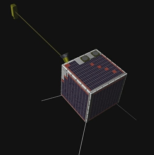
FedSat design model Note the long boom on which was mounted a magnetometer.
| 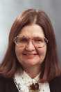
The revamp of this historic webpage is dedicated to Dr Elizabeth Essex-Cohen (1940-2004)
who in 1974 was the only Australian involved in the design of
the US Air Force satellite navigation system NAVSAT, initially conceived of as a purely military system, later renamed GPS,
and made generally available when Selective Availability was turned off in May 2000.
After her initial contribution in the GPS design stage,
she returned to the US Air Force Geophysical Research Station in 1978
as a NASA Senior Post-doctoral Fellow, engaged then in basic ionospheric studies.
Returning to Australia in 1979 , she actively continued her research on the ionosphere,
and was active in lobbying for the second Australian satellite, FedSat.
She was in charge of GPS science program for FedSat.
| Sadly she suddenly became seriously ill, and was hospitalised in the Xmas following the actual launch of FedSat. She had a partial remission in January 2004, enabling her to participate in an International Beacon Satellite Workshop held in Hobart, January 2004. But she then relapsed, and passed away in March 2004. After her death, a huge manual was found amongst her books, which was the Operators Manual for a Satellite of the 1960's; on her death she was probably the only Australian with over 35 years involvement with satellite technology. To fully appreciate Elizabeth's pioneering work one needs an overview of GPS, while on this page an account is given of the GPS satellite constellation system, and brief explanation how and why the ionosphere interfere's with the use of GPS A selection of Elizabeth's scientific papers is available here, whilst the account of her lifelong involvement in GPS is detailed on this web page | |
|
Site Index
Space Physics Department, La Trobe University, Melbourne, Australia |
 NEWS ABOUT SATELLITES