Black Hole
Above
Australia in Space
a History

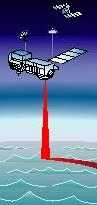
Bouncing radar off the sea
CRC
for
Satellite
Systems
|
|
Black Hole Above |
Australia in Space a History |
|
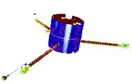
TOPEX-POSEIDON
Bouncing radar off the sea |
CRC for Satellite Systems |
|
|
|
Australian Defence Forces have commenced a study to "investigate the integrity of
GPS equipment in use by Defence.
"
This was announced by the Australian Defence Minister, in August 1999.
Under the investigation, with Global Simulation Systems Limited (GSSL) to supply one Global
Positioning System (GPS) satellite simulator for the Surveillance Systems
Division of the Defence Science and Technology Organisation (DSTO).
t was announced that Glonass, which uses different frequencies for each satellite,
will also be included in the study.
It is not clear whether the study is aimed at overcoming
various simple methods of jamming the GPS Signals,
or in fact, to develop such schemes.
|
|
FROM JAPAN |
FedSat Launch Date Announced Australian Scientific Satellite FedSat will be launched from Japan at a scheduled date in November 2000. This will be in-time for the Centennary of Australia's Federation, from being six separate British colonies, to the union of six states. |

|
Space Dev 100% takeover of SIL (Space Innovations Limited) of Newbury, UK. In their earlier media release Space Dev asserted: We are especially interested in SIL's deep space X-band transceiver capabilities, one of many SIL subsystems applicable to our Near Earth Asteroid Prospector (NEAP), many government missions and other possible SpaceDev deep space missions. SpaceDev now has the ability to design missions, small satellites and spacecraft, to build and test satellites and spacecraft, to perform launch vehicle integration and to build and operate ground control stations. The only missing piece is our own launch vehicle capability Further information is available on SpaceDev's homepages: http://www.SpaceDev.com, and http://www.ctaonline.com/spdv See below |
 PROSPECTOR
| The Lunar Prospector was succesfully launched January 1988. This satellite will initially orbit the moon at an altitude of 100 km, conducting a detailed geophyisical survey of the moon's surface. Special interest attaches to the possible finding of water, which would be exceedingly useful were a space station to be established on (our) moon. |
|
Operational September 1998 |
The Iridium system of satellites, will provide a global mobile phone telephone service. As originally conceived by Motorola, Iridium involved 77 LEO satellites. (Hence the name, as Iridium is element number 77.) The system now pared down to just 66 (= Dysprosium) satellites, each weighing 700 kg, together with six spares. Operational September 1998 In early january 1998, 41 satellites of these 72 had been launched. A good summary of the phone system is given by the Age. |
|
| The Joint Program Office that administers the GPS Program for the US Air Force has announced the discovery of a bug in the code that controls the whole GPS system. s new GPS Millennium Bug will be active during the last 36 hours before the GPS EOW Rollover on August 21 or 22, 1999. The bug, or is it really a worm? will cause ground-based or aircraft GPS receivers to reset to an invalid value This new bug is discussed along with previously known GPS and Y2K bugs affecting GPS at Millennium Bug and Millennium Satellite |
|
FIRST SPACE WALK |
 First Extravehicular Activity
by an Japanese astronaut:
First Extravehicular Activity
by an Japanese astronaut:
Takao Doi and NASA astronaut Winston Scott grabbed malfunctioning spinning satellite from the shuttle Columbia, 25 November, 1997 |
 Oz Kids Into Space
|
Oz Kids Into Space
The First State Based Space School for High School students, was held in Adelaide, South Australia, November 9-11, 1997. Conference hosted NASA astronaut Dr. Scott Parazynski, who did a 5 hour spacewalk outside Mir, from STS-8. Details from Mike Roach |
|
Near Earth Asteroid Prospector |
Commercial Space Exploration & Development of Space Resources At a news conference held in Washington, DC on September 9th, SpaceDev announced the formation of its Near Earth Asteroid Prospector ("NEAP") mission. NEAP consists of building, testing, and launching the world's first private planetary exploration probe. The NEAP spacecraft will carry three state of the art, data gathering/reporting scientific instruments including an alpha-proton-x-ray spectrometer (a duplicate of the instrument used on NASA's recent Mars Sojourner Rover), a neutron spectrometer and a multi-band CCD camera. "NEAP" is unique," said Jim Benson, chairman of SpaceDev "because for the first time, government agencies, universities and institutes around the world will be able to buy insured rides for their experiments and instruments on a fast turn around planetary mission offered by a private company." Although SpaceDev intends to use existing and proven technology, no assurance can be given that the company will have adequate funds to implement its business plan or that the business plan will be successful. The business plan currently calls for an expected first launch in 1999. See NEAP Digest |
|
|
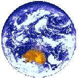
OZONE LOSS IN THE STRATOSPHERE
Ozone depleted regions -- which freely admit harmful ultraviolet rays -- called Black holes -- appear in the stratosphere over arctic and antarctic regions during the (corresponding) summer. Some of this depletion is natural, as ozone concentration builds up during winter, but there is compelling evidence for man-made chemical role in catalytic and other enhancement of the depletion process. Best source of information is via links on the NASA Earth Science Project Home Page.
|
|
1997 Nobel Prize
1997 Physics Nobel Prize for Work Vital to GPS
| The 1997 Nobel Prize for Physics was awarded to
This work will in due course lead to more precise atomic clocks for use in GPS and space navigation in general. See All About GPS. In detail, the increased accuracy in atomic clocks could reduce timing errors in GPS location to the order of millimeters, so that the major component of GPS location error will become ionospheric irregularities not compensated, amounting to about 30m. This work thus given added momentum to studies of the ionosphere, such as those included in the CRCSS FedSat 1 Mission |
|
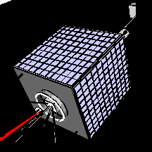
Australian Satellite
FedSat 1
gets go-ahead.
Canberra. Australian Minister of Science has announced in a press release government funding of $A20 million towards an Australian equivalent to NASA, called the Cooperative Research Centre for Satellite Systems. (CRCSS) The CRCSS will launch a scientific satellite FedSat 1, in 2001, the centenary of Australian Federation, when six separate states became a single nation. FedSat will be engineered in Australia, but unlike the first Australian satellite, WRESAT, which was launched from Woomera, South Australia, in 1967, FedSat will be launched overseas. Notable feature of FedSat will be use of on-board GPS receiver, monitoring signals from GPS and Glonass satellites, to study the ionosphere and plasmasphere, and using GPS signals just grazing the earth ("near occultation") to gain cheaply atmospheric data (temperature, pressure) for real-time meteorology. Further information: |
 r
r
|
SUNSAT
the Stellenbosch UNiversity SATellite
is a new experimental satellite under construction by students at the University of Stellenbosch, South Africa. This
satellite is similar to the UoSATs built by the University of Surrey.
It is larger though,
dimensions are 45x45x60
compared to Surrey LEO at
30x30. SUNSAT will carry a JPL GPS receiver supplied by NASA,
and will be
launched by NASA from Vandenberg Air Force Base on an Air Force Delta II
rocket.
Further details: http://sunsat.ee.sun.ac.za/
A text-only summary of the SUNSAT Project and its rationale is at the URL:
http://sunsat.ee.sun.ac.za/sspapers/sats.95/sats.html |

| CNN in Depth SPACE , is a comprehensive listing of CNN special coverage of major space shuttle, satellite and planetary events since the inception of CNN Interactive in August of 1995. "On the right, you'll find brief descriptions and links to each section, while on the left, we've created a showcase of multimedia material highlighting some of the more memorable moments. " |
| TERRIERS A Microsatellite developed at Boston University and other institutions, TERRIERS is a scientific research project involving a combination of satellite and groundbased instrumentation which will make daily global measurements of the earth's ionosphere and thermosphere. TERRIERS is one of two microsatellite projects funded by NASA. Launch now delayed to 1998. One of the TERRIERS leaders, Dr Michael Mendillo, of Boston University, collaborated with Australian Dr Elizabeth Essex in shuttle-based experiments. |
|
| Cluster. This experiment of the European Space Agency involved four identical satellites designed to examine the interaction between the Earth's magnetic field and particles from the Sun. The space craft were each 1200 kg with 72 kg payload for experiments. However, there was a malfunction at the Ariane-5 launch on Tuesday, 4 June 1996. See ESA press release |
|
Lewis was launched August 22, 1997 Sad story of another mission failure. The 385-kg earth observation satellite was built for NASA by TRW as part of NASA's new "faster, cheaper, better" philosophy. Satellite launched into orbit OK but is now spinning out of control. |
|
|
RXTE Satellite MissionNASA Rossi X-ray Timing Explorer (RXTE)
using X-rays to study white dwarfs, neutron
stars, and black holes.
Yahoo Search
Also RXTE Learning Center - educational site that contains information on the satellite RXTE, x-ray astrophysics, and lesson plans which utilize real data. |
|
| Centre for Satellite Engineering Research at the University of Surrey. Focus on microsatellites. Publisher of the International Journal of Small Satellite Engineering Also of special interest is listing of GPS receivers on-board small satellites |
|
STARTING PAGE | SPACEBORNE GPS INFORMATION SITE maintained at the University of New Brunswick. |
|
|
The press release looks familiar, but the story is way out of this world, solar system, and galaxy. Its astronaughty, but suitable for children. |
|
| |
|
FIRST COSPAR COLLOQIUM ON MICROSATELLITES Tainan, Taiwan 14-17 December 1997 |
International Conference Venue: Institute of Aeronautics and Astronautics National Cheng Kung University Tainan, Taiwan 14-17 December 1997 Conference forward It has become increasingly clear that small satellites and microsatellites will play important roles in space research and application. This trend is particularly important for countries with emerging capabilities in high technology and scientific applications in space. Because of the faster and cheaper approach, microsatellites can be used as a versatile tool for scientific researches (Earth observations, space physics, astronomy and micro-gravity study) as well as for commercial users. Full details at the URL: http://rpv.iaa.ncku.edu.tw/program.htm |
|
ASTRONAUTICS FEDERATION IAF-98 Melbourne 20Sept - 2 Oct 1998 |
The annual conference of the International Astronautical Federation (IAF) -will be held for the first time in Australia between 20 September and 2nd October, 1998, at Melbourne. >remember '98 ... start planning papers and attendance now!! > > >Details: EC (Chris) Graham > |\ Technology Development > /\/""|_| \ CSIRO Office of Space Science & Applications > / \ Australian National University Campus > / \ ANUTech Court, cnr North and Daley Roads > ( chris@cossa ) ACTON CANBERRA ACT AUSTRALIA 2601 > \ ___/\ */ (06 or int-61-6)-216-7206 'phone direct > \_/ \__/ -7200 'phone switch > v -7222 facsimile |
|
Altimetry and GPS Surface Reflections Workshop Jet Propulsion Laboratory, Pasadena, California December 2-4, 1997 URL:http://sideshow.jpl.nasa.gov:80/gpsiono/idswkshop/ |
|
and GPS |
All about satellites |
Answering the question "what's in a satellite" an overview of satellite features and engineering for general interest and projects. |
|
|
GPS Signal Science in the
CRC for Satellite Systems |
|
Home Page of the Australian
CRC for Satellite Systems |