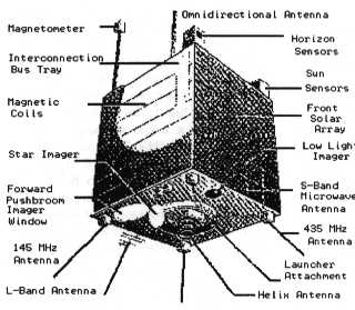
Cut-away diagram of South African SUNSAT satellite.
SUNSAT is a microsatellite, only 45 cm x 45 cm x45 cm. Satllites, except for those embarking on journeys distant from the sun, are powered by batteries that are kept charged by the output from solar cells. n the cae of SUNSAT, the solar cells are directly mounted on the sides. For this amll area of solar cells, power is limited to about 50 watts. Larger satellites have extensive external panels of solar cells mounted on attached wings, supplementing those directly mounted on the satellite case, to meet power needs.
The star imager is viewing the sky, and inputting to the on-board computer. By reference to a built-in star map in memory, the on-board computer determines the orientation of the satellite in space.
At the top of the satellite, mounted on a boom, is a magnetometer for measuring magnetic fields in space. The boom is required to isolate the coils of the magnetometer from the many other aerials mounted on the satellite.
Note the omnidirection antennae on the top of the satellite, so that this low earth orbitting (LEO) satellite can receive signals from GPS satellites above, and at other orientations. The GPS receiver on-board enables on-board space location to be determined. Before the advent of GPS, very precise tracking was required to enable sensing data to be fixed in space.
 Artists impression of
NASA
RXTE Satellite
Note that the body of this satellite is covered with gold
foil as a protective measure.
This is usual for larger satellites of longer or critical mission
durations.
Artists impression of
NASA
RXTE Satellite
Note that the body of this satellite is covered with gold
foil as a protective measure.
This is usual for larger satellites of longer or critical mission
durations.
|
Julian Day Computation
Calculations involving satellites are simplified by using the Jalian
Day rather than our standard (gregorian) calendar.
Here is an example: The GPS Satellite system produces data with week and day starting at 0000 hours January 6, 1980. The signal data packages the week data in 10 bit, so that as 2^10 = 1024, there will a rollover after 1024 weeks. When does the GPS EOW rollover take place? Computation: 1024 weeks = 1024 * 7 = 7168 days 6 Jan 1980 == 2444244.5 Julian Day 2444244.5 + 7168 = 2451412.5 Jaulian Day 2451412.5 == 22 Aug 1999 So the GPS EOW rollover takes place on 22 Auguat, 1999 See GPS Millennium Bug and All about GPS In the above calculation, I've used a Julian/Gregory Converter to convert from a date in the (usual) Gregorian Calendar, to the corresponding Julian Day, and back. A good Julian/Gregory Converter is at: http://quasar.as.utexas.edu/BillInfo/JulianDateCalc.html |

|
Black Hole Above |
Australia in Space a History |

|
TOPEX-POSEIDON
Bouncing radar off the sea |
CRC for Satellite Systems |
|