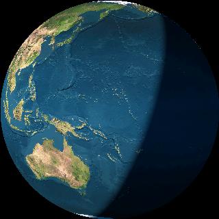
View from AUSSAT 2 (a geostationary satellite)
35776 km above 13'N 164 3'E (near Hawai)
Time: 1997/07/31 6:13:30UTC
The image on the left is what an observer would have seen, minus clouds, but is 100% computed.
- First the current position of the satellite
is computed.
This is done using orbital parameters.
The orbital parameters for Aussat 2 on July 30, 1997,
in NASA/NORAD "two line element" format, were
AUSSAT 2
1 16275U 85109C   97209.58089365 -.00000102  00000-0  10000-3 0  1186
2 16275   3.2469  69.5757 0002638 119.0543 130.7459  1.00271556 32582
- The second task is to compute the actual view from that location in space, when looking towards the centre of the earth. This is done using a complete library (whole earth) of earth shots, which has been put together as a (flat) montage, which is mathematically rolled onto the curved surface of the sphere.
- The line of the day - nite boundary is easily computed, and marked on the image. The night side of the line is in fact very crudely rendered.
- In a better version of the earth view program, not on line, clouds are added to the image, using recent cloud cover images taken from environmental satellites.
| View the Earth from orbiting satellite or shuttle |