|
A Sampling of Elizabeth's Papers on Ionospheric Physics, GPS, and Remote Observation via Satellite.
In almost all her publications, Elizabeth Essex-Cohen is cited by her maiden name.
In a few papers she is
called E.A. Cohen,
A female geophysicist never permitted by Australian authorities to travel to Macquarie Island or the Australian
Antarctic Territories, she supervised research conducted
on Macquarie Island
and at the Casey station in Antarctica.In the later period of her research was
utilising TOPEX and GPS satellites in furtherance of researching the ionosphere/plasmasphere above
the region about
Antarctica - notably the
Weddell Sea
Her finest work was in devising a program for comprehensive 2D imaging of the ionosphere using GPS sateltites,
the just established GPS ground stations in conjunction with the proposed FedSat Australian research satellite.
This program placed
online in brief in 1997
achieved its outstanding goals through her last three PhD students,
Phillip Webb, Irena Horvath, and Endawoki Yizengaw, and also utilising software first developed by a previous
research student, Michael Malos. Sadly she died suddenly in 2004,
so did not receive full recognition for her role in the significant outcomes of the research program she designed and instigated
which lead to
three landmark papers,
two of which were published in Geophysical Research Letters in 2005 and 2006.
- First tomographic image of ionospheric outflows
-
Proof through imaging of a long-standing conjecture that the ionospheric trough is the signature of a boundary in the magnetosphere.
while the third was Elizabeth's joint paper -
E. Yizengaw, P. L. Dyson, E. A. Essex, M. B. Moldwin,
Comprehensive ionosphere dynamics study over the Southern Hemisphere
during the severe magnetic storm on 31 March 2001
Annales Geophysicae, 2005, 23, 707-721
with abstract below followed by plots of the motion of the enormous TID of that date
fingering into space. See also
significance of tracking a TID
|
|
2007
Abs
|
 E. Yizengaw,
M.B. Moldwin,
P.L. Dyson,
E.A. Essex,
Using tomography of GPS TEC to routinely determine average electron density profiles
, Journal of Atmospheric and Solar-errestrial Physics,
Vol 69(3), pp 314-321
E. Yizengaw,
M.B. Moldwin,
P.L. Dyson,
E.A. Essex,
Using tomography of GPS TEC to routinely determine average electron density profiles
, Journal of Atmospheric and Solar-errestrial Physics,
Vol 69(3), pp 314-321
This was Elizabeth Essex-Cohen's last paper, published 3 years after her
untimely death. The first author Endawoke Yizengaw, was Elizabeth's PhD student, following her program
for GPS related research. Following her death, Peter Dyson, continued the supervision, while Moldwin also contributed
to this very interesting paper in the top journal JATP.
The availability of tomographic profiles of the ionosphere derived
from ground based observation
of GPS satellites permits more effective analysis. A copy of this papers abstract is
here
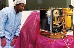
In a clean room in Melbourne early in 2002 PhD student
Endawoke Yizengaw examines the FedSat satellite prior to launch.
|
|
2006
|
E. Yizengaw,
P.L. Dyson,
E.A. Essex†,
A study of the spatial density distribution in the topside ionosphere and plasmasphere using the
FedSat GPS receiver, Advances in Space Research
Volume 38, Issue 11, 2006, pp 2318–2323.
† Deceased in March 2004
Abstract
The spatial electron density distribution observations using the Global Positioning System (GPS) receiver
onboard, the Australian research micro satellite FedSat, are being used to investigate more detailed
information about the topside ionospheric and plasmaspheric density distribution than can be obtained
using ground based receivers. This is because with ground based receivers, the topside ionosphere and
the plasmasphere contribute only a small fraction to the total electron content and so the measurements
are dominated by the higher ionospheric structure at the F2 peak. Being in a polar Low-Earth Orbit
(LEO), and with a GPS Total Electron Content (TEC) sampling rate of 10 s, FedSat is capable of covering
a large area of interest within short period of data sampling period which is very important to obtain
realistic electron density profiles of the topside ionosphere and plasmasphere. The GPS data from FedSat
can be divided into two types: GPS below-the-horizon data that is recorded when FedSat detects GPS signals
that have traversed the ionosphere below FedSat’s orbiting height, GPS above-the-horizon data that
is recorded when FedSat receives signals that have crossed the ionosphere above its orbiting height.
FedSat’s GPS below-the-horizon data can be used to supplement ground based GPS data to provide tomographic
reconstruction with better resolution. FedSat’s GPS above-the-horizon data can be used by itself to
obtain the electron density distribution of the topside ionosphere and plasmasphere using tomographic
reconstruction technique. For this paper we have used only above-the-horizon data to obtain the
topside ionospheric electron density distribution during both geomagnetically quiet and severe
storm-time conditions.
Keywords
FedSat;
Topside ionosphere;
Plasmasphere;
Tomography
|
|
2005
|
E. Yizengaw, P. L. Dyson, E. A. Essex, M. B. Moldwin,
Comprehensive ionosphere dynamics study over the Southern Hemisphere
during the severe magnetic storm on 31 March 2001
Annales Geophysicae, 2005, 23, 707-721, 2005 doi:10.5194/angeo-23-707-2005, 2005.
Abstract
The effects of the 31 March 2001 severe magnetic storm on the Southern Hemisphere
ionosphere
have been studied using ground-based and satellite measurements. The prime goal of this
comprehensive study is to track the ionospheric response from high-to-low latitude to
obtain a clear understanding of storm-time ionospheric change. The study uses a combination
of ionospheric Total Electron Content (TEC) obtained from GPS signal group delay and phase
advance measurements, ionosonde data, and data from satellite in-situ measurements, such as
the Defense Metrological Satellite Program (DMSP), TOPographic EXplorer (TOPEX), and solar
wind data from the Advanced Composition Explorer (ACE). A chain of Global Positioning System (GPS)
stations near the 150° E meridian has been used to give comprehensive latitude coverage extending
from the cusp to the equatorial region. A tomographic inversion algorithm has been applied to the
GPS TEC measurements to obtain maps of the latitudinal structure of the ionospheric during this
severe magnetic storm period, enabling both the spatial and temporal response of the ionosphere
to be studied. Analysis of data from several of the instruments indicates that a strong density
enhancement occurred at mid-latitudes at 11:00 UT on 31 March 2001 and was followed by equatorward
propagating large-scale Travelling Ionospheric Disturbances (TIDs). The tomographic reconstruction
revealed important features in ionospheric structure, such as quasi-wave formations extending
finger-like to higher altitudes. The most pronounced ionospheric effects of the storm occurred at
high- and mid-latitudes, where strong positive disturbances occurred during the storm main phase,
followed by a long lasting negative storm
effect during the recovery phase. Relatively minor storm effects occurred in the equatorial
region.
Webmaster's Note:
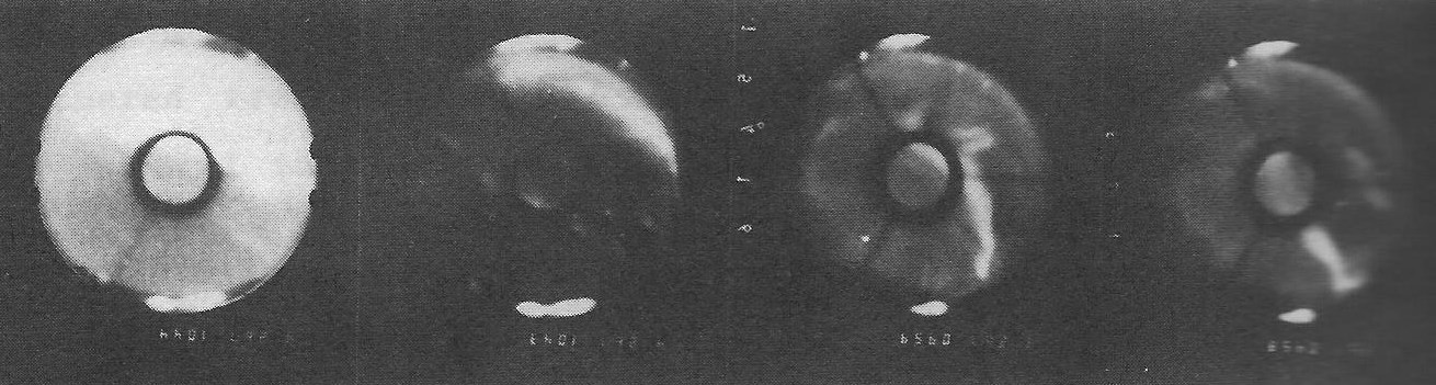
The extraordinarily tall (~400km) relativey narrow (~5 degrees latitude) plasma spikes extending "finger-like" upwards
as delineated in Figure 6 (b) and (c) of this 2005 Annales Geophysicae paper.
Note that these two figures differ by approximately 30 minutes and are (tomographic)snapshots
of what is called a TID = Travelling Ionospheric Disturbance, bizarely similar -- though inverted - to an (atmospheric) hurricane.
|
The quasi-wave formations extending finger-like to higher altitudes referred to in the abstract immediately above
have been interpreted as Rayleigh-Taylor phenomena by
Brett Carter of
SPACE Research Centre
at RMIT Carter gained
his PhD at La Trobe University Space Physics and then carried out
post-doc research with Endowoki Yizengaw at Boston University.
To the left is numerical modelling of this phenomena included in the article Predicting daily space weather will help keep your GPS on target
|
|
|
2004
 |
Endawoke Yizengaw, P. L. Dyson, and E. A. Essex,
Tomographic reconstruction of the ionosphere using ground-based
GPS data in the Australian region
Workshop on Applications of Radio, WAR2004, [ Conference papers on Conference CD, and at
https://bing.bc.edu/endawoke-kassie/Publications/Yizengaw-WAR04.pdf ]
Abstract
This paper describes the experimental procedures of tomographic imaging techniques that
have been developed and
used at La Trobe University. Tomographic imaging provides a powerful technique for
obtaining images of the
ionospheric electron density distribution, and is a relatively new technique which has
promising features to supplement
the most expensive ground-based vertical sounding instruments such as ionosonde and
incoherent radar. The technique,
which involves monitoring radio transmission from Global Positioning System (GPS) along
a meridional chain of
ground based receivers, has particularpotential for complementing temporalmeasurements
by other observing
techniques such as ionosondes. The tomographic inversion algorithm has been applied to
actual GPS-based total
electron content (TEC) measurements obtained during two severe magnetic storm periods
(18 August 2003 and 31
March 2001). The tomographic reconstruction presented here revealed important features
in ionospheric structure such
as ionization troughs and quasi-wave formations. Electron density profiles obtained by
the tomographic reconstruction
method are in excellent agreement with profiles obtained by ionosondes at or near the
GPS receiver stations, confirming
the validity of the tomographic algorithm that has been developed. Geophysical
interpretations of the observations are
also presented.
Key words:Tomographic reconstruction, TEC, and GPS
|
|
2003
|
I. Horvath and E. A. Essex
The Weddell sea anomaly observed with the Topex satellite data
Journal of Atmospheric and Solar-Terrestrial Physics
Volume 65, Issue 6, April 2003, Pages 693–706
Abstract
This paper introduces the complete image of the Weddell Sea Anomaly, observed with the over-the-ocean ionospheric total
electron content (TEC) values obtained from the TOPEX satellite data with an almost unlimited coverage over the oceans,
the first time according to the literature; and investigates its development. With a series of TOPEX TEC maps, this
paper demonstrates the diurnal variations of both the night-time and the day-time Weddell Sea Anomaly, which appeared
as a night-time TEC enhancement and as a day-time TEC depletion, during the near sunspot maximum period of 1998 and 1999
investigated. Several TOPEX passes, plotted in geomagnetic latitudes, are also presented to demonstrate the longitudinal
variations of the Weddell Sea Anomaly, and also to show other ionospheric features appearing such as the southern-hemisphere
mid-latitude day-time and night-time trough, the northern-hemisphere mid-latitude night-time trough and the equatorial anomaly.
This paper demonstrates how large the anomaly is in reality situated west of the Faraday ionosonde station over the Bellinghausen
Sea and not over the Weddell Sea that is east of Faraday. Thus the correct name should be Bellinghausen Sea Anomaly. Based upon
the review paper of Dudeney and Piggott (1978), the development of the Weddell Sea Anomaly is explained with the combined effects
of solar ultraviolet radiation and thermospheric neutral winds.
Keywords
Weddell Sea Anomaly;
Antarctica; Mid-latitude ionospheric trough;
South Atlantic Magnetic Anomaly;
TOPEX;
TEC
Availability: Paper is downloadable for a fee here
|
2000
|
I. Horvath and E. A. Essex
Using observations from the GPS and TOPEX satellites to investigate night-time TEC enhancements at
mid-latitudes in the southern hemisphere during a low sunspot number period
Journal of Atmospheric and Solar-Terrestrial Physics,
Volume 62, Issue 5, 15 March 2000, pp 371–391.
Abstract
The state of the ionization of the upper atmosphere at low and mid latitudes in the Australian region
has been studied by investigating the total electron content (TEC) obtained by a dual-frequency group
path and phase path GPS technique. For the low sunspot number time period of March 1995–February 1996,
one week of data centred on the Priority Regular World Day for each month have been used to investigate
night-time mid-latitude peaks occurring around midnight in the Australian region. TEC from TOPEX
provided additional information related to the formation of the night-time peaks. Although night-time
TEC enhancements have been observed previously, there is no general agreement on their origin. From the
results of the present study, the development of midnight TEC enhancements coincided with the low
latitude processes occurring at around the time of vertical ExB drift velocity reversal. The TOPEX
results confirmed that the upward E×B drift velocity reversal and the downward plasma flow from
greater heights producing the night-time peaks at mid latitudes are triggered from a common source:
the westward electric field.
Availability: Paper is downloadable for a fee.
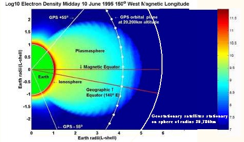
CONCLUSIONS
LEO micro satellites such as the planned FedSat provide the opportunity for researchers in Space Sciences to further investigate those regions of the ionosphere
for which existing equipment and techniques are either difficult or impossible to apply. In the future, constellations of microsatelites
may provide a global coverage of the ionosphere previously not possible with ground based equipment.
WEBMASTER COMMENT
The data that Elizabeth and her PhD student analysed was supplied by the US Government funded
Topex-Poseidon Project. The Project
was required to make its satellite acquired data freely available to researchers world-wide.
So very different from using a ground-based rotating antenna to acquire TEC !! Hence their conclusions
about the great utility of LEO satellite observation for ionospheric study.
|
2000

|
E A Essex, P A Webb, I Horvath, C. McKinnon, N. Shilo and B. Tate
Cooperative Research Centre for Satellite Systems
Department of Physics, La Trobe University, Bundoora, Victoria 3083, Australia
Abstract
Recently, with the escalating cost of large satellite missions, attention has turned to
smaller satellites. Their advantages of low overall cost in construction and launch, and
short time span between conception and launch has given a new impetus to the further study
of the geosphere. By using a combination of space-based and ground-based receivers, it is
possible to undertake new and exciting experiments directed towards furthering our knowledge
of the ionosphere. Combinations of high earth orbit satellites, such as the Global
Positioning System (GPS), and low earth orbit (LEO) microsatellites are providing the
capability for satellite to satellite occultation experiments to reconstruct the vertical
profile of the ionosphere. The topside ionospheric and plasmaspheric ionisation content may
also be explored with satellite to satellite experiments. This paper describes some of the
experiments proposed for future microsatellites, such as those planned for the Australian
satellite FedSat.
Also available www.ips.gov.au/IPSHosted/STSP/meetings/aip/lizabeth/essexv4.htm
|
|
1999
|
I. Horvath and E. A. Essex
Investigating Southern Hemisphere Mid-Latitude Nightime TEC Enhancements During Low Sunspot
Number Period with GPS and TOPEX, Proceedings, IES 99, Ionospheric Effects Symposium,
Alexandria, Virginia, May 4-6, 1999,
pp 6B4-1--6B4-8
Abstract
The state of the ionization of the upper atmosphere at low and mid latitudes in the Australian region has been
studied by investigating total electron content (TEC) obtained by the dual-frequency group path and phase path
Global Positioning System technique. For the low sunspot number time period of March 1995-February 1996, one week
of data centered on the regular world days for each month have been used to investigate nighttime mid-latitude
peaks occurring around midnight in the Australian region. TEC from TOPEX provided additional information related
to the formation of the nighttime peaks. Although nighttime TEC enhancements have been observed previously,
the origin of these large increases does not have general agreement among researchers. From the results of the
present study it appears that the development of midnight TEC enhancements is a direct consequence of the low
latitude processes occurring at around the time of ExB drift velocity reversal. Accordingly the midnight TEC
enhancement appears to be a reverse-fountain-related formation at mid latitude and the primary source of plasma
is the reverse fountain. The monthly GPS plots show a seasonal variation of nighttime TEC enhancement. TOPEX
data plots provided the spatial variability of large-scale ionospheric features under different geomagnetic
conditions during the season of autumnal equinox.
|
|
1999
|
P. A. Webb and E. A. Essex
A Global Ionospheric-Plasmasphere Model: Application to GPS, Proceedings, IES 99, Ionospheric Effects Symposium,
Alexandria, Virginia, May 4-6, 1999,
pp 5A1-1--5A1-8
Abstract
With the recent advent of GPS satellites as a research tool in studying the ionized regions that surround
the Earth a need has arisen for a simple yet accurate model for plasmasphere, the region above the ionosphere.
A dynamic model based on diffuse equilibrium will be described, which is combined with the International
Reference Ionosphere model to produce a global ionosphere-plasmasphere model.
Some preliminary results from the model are presented and discussed.
|
|
1998
|
B. S. Täte, N. M. Shilo, E. A. Essex,An Investigation of the Ionosphere in the Southern High Latitudes
During Low Sunspot Numbers, Acta Geodaetica et Geophysica Hungarica
March 1998, Volume 33, Issue 1, pp 83-90.
Abstract
During the period of 1993–1996, the transmissions from the US Navy Navigational Satellite System (NNSS) polar
orbiting satellites, received at Casey (66.28 degrees
S, 110.5 degrees E), Antarctica were used to investigate
the amplitude scintillations on 150 MHz and the Ionospheric Total Electron Content obtained using the
Differential phase technique. The differential phase technique, measuring the phase difference between
the two coherent transmissions on 150 MHz and 400 MHz from the NNSS satellites, permits only relative
TEC changes to be calculated. Absolute TEC is estimated from the relative TEC using the f0F2 obtained
from the digisonde records from Casey station or from GPS measurements. A JMR-1 satellite receiver system
is used to obtain the phase and amplitude data, with all measurements logged on a PC. A special antenna
with high gain at high elevation enabled the reception of high quality signals from the NNSS satellites.
Scintillation measurements were obtained from a purpose built receiver, attached to the 24 MHz IF output
of the JMR. Investigations of the ionospheric enhancements known as polar patches, and the depletions,
known as polar holes were carried out. In order to locate the patches and polar holes, the TEC data are
mapped in MLT magnetic co-ordinates. Comparisons to results similarly obtained from GPS satellites are
also made. The results obtained are in agreement with the earlier findings. However, comparisons with
models indicate large discrepancies when patches and holes are present.
|
|
1997
|
E.A. Essex, P. Webb, I. Horvath. and H.A. Cohen, The
Use of Microsatellites in Monitoring the Ionosphere/Plasmasphere
in Proc. COSPAR Colloquium on Microsatellites as Research Tools,
Ed. F.-B Hsiao, at National Cheng Hung Uniiversity Tainan, Taiwan, 15-17
December, 1997 COSPAR Colloquia Series 10, pp276-279
Abstract
The advent of microsatellites with their advantages of low overall cost in construction and launch and
short time span between conception and launch has given a new impetus to the further study of the geosphere.
By using a combination of space based and ground based receivers it is possible to undertake new and exciting
experiments directed towards furthering our knowledge of the ionosphere. Combinations of high earth orbit
satellites such as GPS and low earth orbit (LEO) micro satellites are providing the capability for satellite to
satellite occultation experiments to reconstruct the vertical profile of the ionosphere. The topside ionosphere
and plasmasphere ionisation content may also be explored with satellite to satellite experiments. This paper
will describe some of the experiments proposed for future micro satellites such as those planned for the
Australian FedSat1 satellite. Model studies of some of these experiments will be discussed.
|
|
1994 |
H.M. Beggs*, E.A. Essex†, and D. Rasch,
Antarctic polar cap total electron content observations from
Casey Station,
Journal of Atmospheric and Terrestrial Physics
Volume 56, Issue 5, April 1994, pp 659–666.
Abstract
In early 1990 a modified JMR-1 satellite receiver system was installed at Casey Station, Antarctica
(g.g. 66.28°S, 110.54° E, -80.4°A, magnetic midnight 1816UT, L = 37.8), in order to monitor the differential
phase between the 150 and 400 MHz signals from polar orbiting NNSS satellites. Total electron content (TEC)
was calculated using the differential phase and Casey
ionosonde foF2 data, and is presented here for near
sunspot maximum in August 1990 and exactly one year later. The data are used to investigate long-lived
ionization enhancements at invariant latitudes polewards of - 80° A, and the ‘polar hole’, a region
from -70 to - 80° A on the nightside of the polar cap where reduced electron densitiy exists because
of the long transport time of plasma from the dayside across the polar cap. A comparison is made between
the Casey TEC data and the Utah State University Time Dependent Ionospheric Model (TDIM) which uses
as variables the solar index (F 10.7), season (summer, winter or equinox), global magnetic index (Kp),
IMF By direction, and universal time (UT)
|
|
1993
|
M. Mallis and E. A. Essex, Diurnal and seasonal variability of the southern-hemisphere main
ionospheric trough
from differential- phase measurements, J. Atmos. Terr. Phys., vol. 55, pp. 1021-1037, 1993
Abstract
A differential-phase technique utilizing the radio transmissions of NNSS satellites was used to make
measurements of the latitudinal variations of ionospheric vertical total electron content (TEC) in the
southern mid-latitude trough region from the location of
Macquarie Island
(a cis-auroral site;
geographic coordinates 54.5°S, 154.95°E, geomagnetic coordinates 64.5 S, 177.67 E, L = 5.38) for a
period of 14 months during 1987–1989. The differential-phase method provided a means of observing a
relatively large expanse of ionosphere whilst centered on the cis-auroral region which was well suited
for trough studies. By monitoring the two transmitted radio signals at 150 and 400 MHz from the Navy
Navigation Satellite System (NNSS) polar orbiting satellites it was possible to deduce the latitudinal
variation of ionospheric vertical TEC for the duration of the satellite pass. The absolute TEC was derived
from Faraday-rotation and ionosonde data obtained during the same period.
The main findings of this work have been the high incidence of daytime troughs for all seasons and
the relative low incidence of night-time troughs. Both summer and vernal equinox seasons display a
greater occurrence frequency of daytime troughs than the winter and autumnal equinox seasons.
Winter-time troughs at any time are less frequent than for any other season. Comparisons with the
northern-hemisphere trough display a marked difference in occurrence frequency and distribution of
troughs. An attempt to explain some of these features in the light of the high-latitude convection
theory is offered. Case studies are given for all seasons to highlight these findings.
|
|
1990
|
G.R.A. Ellis and E. A. Essex et al , Radioastronomy through an artificial ionospheric window:
Spacelab 2 observations, Advances in Space Research 8(1):63-66, 1990
Abstract
Abstract
Observations of the galactic background radio emission at a number of frequencies between 2.75 MHz and 0.51 MHz were made
in association with the Spacelab-2 plasma depletion experiments to test the concept of making low frequency observations
through an artificially created window. Following the Shuttle OMS burn at a time when foF2 was 1.99 MHz, a decrease in the
maximum ionospheric electron density of approximately 30% occurred. The first observations of the radio emission at 1.704 MHz
at high galactic latitudes with
good angular resolution (25 degrees) were made during this event.
|
|
1987
|
G.R.A. Ellis and E. A. Essex et al , Low-frequency radioastronomical observations during the
Spacelab 2 plasma depletions experiment, The Australian Physicist 24:56-58, 1987
|
|
|
Punching a hole in the Ionosphere
 The fact that major rocket burns can punch a short-lived hole
in the ionosphere was discovered by Michael Mendillo, of Boston University.
Two holes in the ionosphere were deliberated punched in 1985
by firing the thrust rockets of the
Space Shuttle Challenger
over Tasmania and also over Boston. Elizabeth Essex collaborated with a world-wide group of researchers in monitoring this historic experiment.
Such a short-lived hole provides access on Earth and to low orbit Spacelab observers to
astronomical information normally hidden by the ionosphere. Note that Spacelab was an orbiting observatory
in the cargo bay of the Shuttle. Papers describing Spacelab observations during plasma depletion are listed immediately above.
The fact that major rocket burns can punch a short-lived hole
in the ionosphere was discovered by Michael Mendillo, of Boston University.
Two holes in the ionosphere were deliberated punched in 1985
by firing the thrust rockets of the
Space Shuttle Challenger
over Tasmania and also over Boston. Elizabeth Essex collaborated with a world-wide group of researchers in monitoring this historic experiment.
Such a short-lived hole provides access on Earth and to low orbit Spacelab observers to
astronomical information normally hidden by the ionosphere. Note that Spacelab was an orbiting observatory
in the cargo bay of the Shuttle. Papers describing Spacelab observations during plasma depletion are listed immediately above.
|
|
|
1987
|
M. Lambert and E. A. Essex
Studies of Ionospheric Irregularities around L=4 in the Southern
Hemisphere using Satellite Beacons, Proceedings, IES 99, Australian National Antarctic Research Expedition 1987,
ANARE Research Notes 48, 1987, pp198-205.
Webmasters Note
Very large ionospheric Total Electron Content (TEC) fluctuations as seen
from Macquarie Island
and Beveridge (Vic) Field Stations during UTS days 263 and 264, 1984 which were correllated
with dramtic auroral activity as seen at
Macquarie Island
Increases in the nightime TEC of up to 60% in the space of a few minutes were observed.
| From this paper:
Macquarie Island
all-sky camera frames for the universal times: 0958, 0959, 1043 and 1044 on UT day 267, 1984
i.e., for two image pairs only one minute apart.
|
|
|
1986 |
Malcolm Lambert and
E.A. Cohen,
Monitoring ionospheric irregularities in the southern auroral region by means of a satellite beacon,
Radio Science,
Volume 21, Issue 3, May-June 1986, pp 347–350.
Abstract
During 1984 total electron content (TEC) data were gathered from Melbourne, a mid-latitude station,
and from Macquarie Island in the southern auroral zone,
using the Faraday rotation of geostationary
satellite signals. Large-scale fluctuations in the TEC due to auroral activity were observed from
Macquarie Island, and some of these disturbances were seen to propagate towards Melbourne with speeds
of 200 to 1,000 m/s. Large-scale rapid decreases in TEC were observed during the evening hours of
about one third of autumn equinox days studied. These decreases occurred at a geomagnetic latitude of
approximately 60°S and could be associated with the main ionospheric trough
travelling through the ray path from the satellite to the receiving station.
|
|
1984 |
E.A. Cohen,
The study of the effect of solar eclipses on the ionosphere based on satellite
beacon observations, Radio Science
Volume 19, Issue 3, pages 769–777, May-June 1984.
Abstract
Satellite beacon observations during eclipses have provided much information on the behavior of the ionosphere. A combination of Faraday rotation
and differential phase measurements as well as ionosonde data can provide information on the topside and
bottomside ionospheric behavior during an eclipse as well as on the production rate. Recent attention has
been directed toward a study of the dynamics of the F region during an eclipse and the relation between
the amount of depletion in the total electron content and the percent obscuration of the sun. Of particular
interest is the time delay from the maximum obscuration to the maximum depletion of the total electron content.
Further modeling studies are required in order to reproduce the experimental results. Further observations
are also required in order to establish whether TID's are generated following a total solar eclipse as
predicted theoretically. In particular, it appears that a more sensitive technique such as differential
Doppler rather than Faraday rotation is required. The total solar eclipse of June 11, 1983, with its
long totality time of 4–5 min over Indonesia and Papua New Guinea will provide an ideal opportunity
for further studies of these unanswered questions.
|
|
1981 |
E.A. Essex, M. Mendillo, J.P. Schödel, J.A. Klobuchar, A.V. da Rosa, K.C. Yeh, R.B. Fritz, F.H. Hibberd,
L. Kersley, J.R. Koster, D.A. Matsoukas, Y. Nakata, and T.H. Roelofs,
A global response of the total electron content of the ionosphere to the magnetic storm of 17 and 18
June 1972
Journal of Atmospheric and Terrestrial Physics,
Volume 43, Issue 4, April 1981, pp 293–306
Abstract
A global study is made of the response of the total electron content of the ionosphere to the sudden
commencement (S.C.) geomagnetic storm of 17 June 1972. Using data from 18 sites, a comparison is made
of the seasonal differences between this storm and the 17 December 1971 ionospheric storm studied on a
similar global basis by Schödelet al. (1974). When storm induced total electron content enhancements occur,
they generally occur within 24 h of the S.C. and they tend to be larger in the winter hemisphere; subsequent
depletions are generally more severe in the summer hemisphere. The best-defined storm effect is the positive
phase evening enhancements seen in the American longitude sector. The local times of the peak enhancements
show a coupled seasonal/longitudinal/latitudinal pattern with latitude being the clearest ordering parameter.
The magnitudes of the subsequent
negative phase depletions show a longitudinal gradient from east to west.
|
| 1979
|
D. W. Cornelius and
E. A. Essex,
HF Doppler observations associated with spread F
Journal of Geophysical Research: Space Physics,
Volume 84, Issue A4, 1 April 1979, pp 1361–1368.
Abstract
This paper discusses HF Doppler spectrum observations at mid-latitudes when spread F was observed
on local ionograms. The data indicate that Doppler broadening is related to spread F (they both
commence simultaneously). The results can be simulated by using different ionospheric models.
Calculations show that a rippled contour can cause HF Doppler broadening and range spreading
on ionograms if the structure is traveling horizontally. Although this mechanism can lead to
HF Doppler broadening, scattering at 4.5 and 7.5 MHz in an anisotropic medium from near overhead
can also explain the experimental results. The observation of aspect-sensitive scatter does,
however, depend critically on the statistical description of the irregularity spectrum. It is
suggested that an experiment designed to measure the Doppler shift as a function of zenith angle
may enable some of the current ambiguities associated with spread F to be eliminated.
|
| 1979
|
D.W Cornelius and
E.A Essex
Observations of mid-latitude sporadic E using the HF Doppler technique,
Journal of Atmospheric and Terrestrial Physics,
Volume 41, Issue 5, May 1979, pps 481–499
Abstract
Observations of sporadic E using the HF Doppier technique are presented.
An important result is the simultaneous observation of many moving clouds
in the layer. The Doppler shifts expected from various types of moving
irregularities are described, together with assumptions involved in an
estimate of their horizontal velocity. The reflection mechanism from
non-blanketing layers relevant to the horizontal structure observed
is also discussed. It appears that on some occasions partial reflection
can be attributed to dense clouds of ionization seen at off vertical angles.
Accurate group range data together with direction of arrival of radio waves
from the sporadic E-layer are required to confirm this tentative conclusion.
|
|
1978 |
E. A. Essex,
Ionospheric total electron content at southern mid-latitudes during 1971–1974,
Journal of Atmospheric and Terrestrial Physics, Volume 40, Issue 9, Sept. 1978, pp 1019–1024.
Abstract
Measurements of the total electron content of the ionosphere carried out at Melbourne
(37.47°S, 144.93°E geographic co-ordinates) using the Faraday rotation of the signals
from the geostationary satellites ATS-1 and 2F-2 are presented for the period 1971–1974.
The diurnal, seasonal and sunspot cycle effects of the total electron content are outlined
as well as the corresponding slab thickness and hmF2 variations. These results for the
declining phase of the sunspot cycle are similar to those given by Titheridge (1973a) for
similar latitudes for the ascending phase of the sunspot cycle. Using two geostationary
satellites, simultaneous observations of the total electron content were recorded.
For a spatial separation of the 400 km sub-ionospheric point of about 1400 km,
low Kp sum days showed small
differences probably due to gravity waves, whereas high Kp
sum days sometimes showed quite different behaviour.
|
| 1977
|
E. A Essex, High to low latitude variations in the evening summer total electron content and
F-region electron density
- Journal of Atmospheric and Terrestrial Physics, Volume 39, Issues 9–10, September–October 1977, pp 1155–1158.
Abstract
Many workers have reported evening increases in total electron content during the summer.
In this paper an attempt is made to compare the latitude variations on a day to day basis
using geostationary satellite data as well as ?oF2. It is found that on a day to day basis
evening increases at higher latitudes are usually accompanied by large enhancements at
low latitudes. Measurements of neutral air winds and plasma influx are required to determine
the relative importance of these two processes.
|
| 1975
|
E. A. Essex,
Comparison of ionospheric gravity wave periods as measured by different experimental techniques,
Journal of Atmospheric and Terrestrial Physics
Volume 37, Issue 10, October 1975, pp 1349–1356
Abstract
A comparison is made of ionospheric gravity wave periods as measured by several different experimental
techniques. These include high frequency CW doppler, vertical incidence ionosondes, Faraday rotation
measurements of total electron content and refraction of VHF signals from a geostationary satellite.
These observations are found to yield an increase in power at the longer periods as the height increases,
consistent with gravity wave theory.
|
|
1975
|
E. A. Essex,
Ray Tracing Through Realistic Ionosphere Gravity Wave Models: A Comparison with Experimental Data
from Several Different Techniques,
Effects of the Ionosphere on Space Physics and Communications,
Proceedings of Ionospheric Effects Symposium, (Editor John M. Goodman), January 20-22, 1975, Naval Research Laboratory, Washington DC 20375, pp 1349–1356
Abstract
Model ionospheres using experimentally measured parameters are constructed from a realistic medium scale
ionospheric gravity wave model. The ray tracing technique is then employed to simulate the results of the
original experimental measurements from the model ionospheres. The technique is found to be limited by the
gravity wave model which uses only one gravity wave period in the construction of the ionospheric model
whereas realistic ionospheres contain in general a
spectrum of medium scale gravity waves.
 Significance of this paper Significance of this paper
This paper represents a vital part of the work which Elizabeth performed during 1974 at the U.S.Air Force
Geophysical Research Laborator, Hanscom Fields, near Boston. The signicant contribution she made to GPS involved her
tracing of rays emitted from LEO (low earth orbiting) satellites to the Earth's surface,
using the latest available geophysical models
to determine path deviation, Faraday Rotation attenuation, due to ionospheric plasma and the effect of irregularities. This research, done in conjunction with USAF Senior Scientist
Jack Klobuchar
- Showed that - in absence of scintillations - ionospheric effects although significant were not of a scale as to impede
reception of signals from the required minimum number of satellites from the adopted GPS Satellite Constellation.
- Showed that size of ionospheric induced errors required compensation
for ionospheric effects. Klobuchar was developing the
Klobuchar's Model which is effectively broadcast from the GPS satellites.
But how to prove the reliability of her modelling for GPS satellites orbiting at 12,500 miles? Elizabeth applied her modelling effects on wireless signals from geostationary satellites,
( about are up about 22000 miles )
which are similarly affected by the ionosphere.
Now Geo-stat satellites are easy to observe - each one is at fixed altitude and azimuth -- so she was able
to directly test her geophysical model using published observations of various geostationary satellites
- with most striking ability to model the progress of so called gravity waves (in the ionosphere).
With her methods proven by data on the geostats, they could be applied with confidence
to test proposed Satellite constellations for NavSta, leading to the selection of the GPS system involving 24
LEos (+ spares) of 12 hour period as shown in the accompanying diagram.
Text Searchable extract of this paper is here
Later in 1975 in JATP (Journal of Atmospheric and Terrestial Physics) Elizabeth published an authoritative study
of gravity waves,
comparing a range of experimental datas with gravitational wave theory.
|
| 1968
|
Elizabeth A. Essex*,
Periodic fading of ionospheric echoes, Journal of Atmospheric and Terrestrial Physics, Volume 30, Issue 7, 1968, pp 1441–1443, IN3-IN6
doi:10.1016/S0021-9169(68)91328-7
Abstract
A peculiar periodic fading of ionospheric echoes from E, E8 and F-regions is described.
The fading is sometimes present on one magneto-ionic component alone.
* Now at Department of Physics, University of the West Indies, Kingston, Jamaica.
|
| 1968
|
E. A. Essex* and F. H. Hibberd,
Frequency and spatial correlations of fading radio echoes from the ionosphere,
Journal of Atmospheric and Terrestrial Physics, Volume 30, Issue 5, 1968, pp 1019–1031.
Abstract
The cross correlation of the amplitudes of diffusely reflected fading ionospheric echoes on adjacent
frequencies is analysed. The correlation function is measured experimentally for a number of frequency
separations for E-, Es- and F-echoes. Simultaneous measurements are made of the cross correlation at
closely spaced receivers. Comparison of the correlations on adjacent frequencies and at closely spaced
receivers shows that the fading arises very close to the reflection level.
The maximum value of the cross correlation function between echoes on adjacent frequencies
is commonly displaced from zero time. This effect is interpreted as arising from apparent
vertical motions of the ionosphere.
* Now at Department of Physics, University of the West Indies, Kingston, Jamaica.
|